|
| at: |
Davidson River Area |
Data from David Muse
 show on map
 animate
Trail users:


Elevation Profile
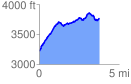
 3.793874 mi
 929.96 ft
 380.85 ft
 549.11 ft
 4.64 %
GPX Downloads: Track Route
![]()
|
| at: |
Davidson River Area |
show on map
animate
3.793874 mi
929.96 ft
380.85 ft
549.11 ft
4.64 %