| at: |
Flint Creek |
Data from USFS GIS
 show on map
 animate
Trail users:


Elevation Profile
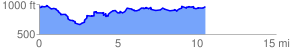
 10.690611 mi
 1862.79 ft
 1862.79 ft
 0.00 ft
 3.30 %
GPX Downloads: Track Route
![]()
| at: |
Flint Creek |
show on map
animate
10.690611 mi
1862.79 ft
1862.79 ft
0.00 ft
3.30 %