| at: |
Kentuck ORV Trails |
Data from USFS GIS
 show on map
 animate
Trail users:


Elevation Profile
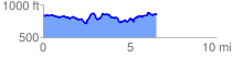
 6.660221 mi
 1254.35 ft
 1254.35 ft
 0.00 ft
 3.57 %
GPX Downloads: Track Route
![]()
| at: |
Kentuck ORV Trails |
show on map
animate
6.660221 mi
1254.35 ft
1254.35 ft
0.00 ft
3.57 %