| at: |
Flint Creek |
Data from USFS GIS
 show on map
 animate
Trail users:


Elevation Profile
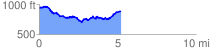
 5.296915 mi
 842.67 ft
 883.50 ft
 -40.83 ft
 3.16 %
GPX Downloads: Track Route
![]()
| at: |
Flint Creek |
show on map
animate
5.296915 mi
842.67 ft
883.50 ft
-40.83 ft
3.16 %