| at: |
Bankhead National Forest |
Data from USFS GIS
 show on map
 animate
Trail users:


Elevation Profile
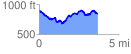
 3.743434 mi
 680.45 ft
 710.05 ft
 -29.61 ft
 3.59 %
GPX Downloads: Track Route
![]()
| at: |
Bankhead National Forest |
show on map
animate
3.743434 mi
680.45 ft
710.05 ft
-29.61 ft
3.59 %