| at: |
Shoal Creek Horse Trails |
Data from USFS GIS
 show on map
 animate
Trail users:


Elevation Profile
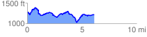
 6.167774 mi
 1146.47 ft
 1210.29 ft
 -63.82 ft
 3.72 %
GPX Downloads: Track Route
![]()
| at: |
Shoal Creek Horse Trails |
show on map
animate
6.167774 mi
1146.47 ft
1210.29 ft
-63.82 ft
3.72 %