|
| at: |
Tuskegee National Forest |
Data from USFS GIS
 show on map
 animate
Trail users:


Elevation Profile
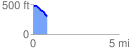
 0.824220 mi
 15.11 ft
 186.37 ft
 -171.26 ft
 4.28 %
GPX Downloads: Track Route
![]()
|
| at: |
Tuskegee National Forest |
show on map
animate
0.824220 mi
15.11 ft
186.37 ft
-171.26 ft
4.28 %