|
| at: |
Tuskegee National Forest |
Data from USFS GIS
 show on map
 animate
Trail users:


Elevation Profile
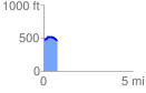
 0.771478 mi
 54.25 ft
 72.60 ft
 -18.35 ft
 1.78 %
GPX Downloads: Track Route
![]()
|
| at: |
Tuskegee National Forest |
show on map
animate
0.771478 mi
54.25 ft
72.60 ft
-18.35 ft
1.78 %