|
| at: |
Tuskegee National Forest |
Data from USFS GIS
 show on map
 animate
Trail users:


Elevation Profile
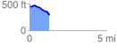
 1.295686 mi
 37.82 ft
 174.87 ft
 -137.05 ft
 2.56 %
GPX Downloads: Track Route
![]()
|
| at: |
Tuskegee National Forest |
show on map
animate
1.295686 mi
37.82 ft
174.87 ft
-137.05 ft
2.56 %