|
| at: |
Tuskegee National Forest |
Data from USFS GIS
 show on map
 animate
Trail users:


Elevation Profile
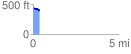
 0.394426 mi
 18.80 ft
 65.81 ft
 -47.01 ft
 3.16 %
GPX Downloads: Track Route
![]()
|
| at: |
Tuskegee National Forest |
show on map
animate
0.394426 mi
18.80 ft
65.81 ft
-47.01 ft
3.16 %