|
| at: |
Tuskegee National Forest |
Data from USFS GIS
 show on map
 animate
Trail users:


Elevation Profile
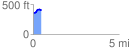
 0.483753 mi
 64.72 ft
 20.49 ft
 44.23 ft
 2.53 %
GPX Downloads: Track Route
![]()
|
| at: |
Tuskegee National Forest |
show on map
animate
0.483753 mi
64.72 ft
20.49 ft
44.23 ft
2.53 %