|
| at: |
Tuskegee National Forest |
Data from USFS GIS
 show on map
 animate
Trail users:


Elevation Profile
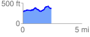
 2.472698 mi
 256.12 ft
 178.14 ft
 77.98 ft
 1.96 %
GPX Downloads: Track Route
![]()
|
| at: |
Tuskegee National Forest |
show on map
animate
2.472698 mi
256.12 ft
178.14 ft
77.98 ft
1.96 %