|
| at: |
Tuskegee National Forest |
Data from USFS GIS
 show on map
 animate
Trail users:


Elevation Profile
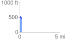
 0.265040 mi
 11.72 ft
 69.15 ft
 -57.43 ft
 4.94 %
GPX Downloads: Track Route
![]()
|
| at: |
Tuskegee National Forest |
show on map
animate
0.265040 mi
11.72 ft
69.15 ft
-57.43 ft
4.94 %