|
| at: |
Tuskegee National Forest |
Data from USFS GIS
 show on map
 animate
Trail users:


Elevation Profile
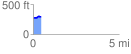
 0.491625 mi
 33.72 ft
 14.27 ft
 19.45 ft
 1.30 %
GPX Downloads: Track Route
![]()
|
| at: |
Tuskegee National Forest |
show on map
animate
0.491625 mi
33.72 ft
14.27 ft
19.45 ft
1.30 %