|
| at: |
Tuskegee National Forest |
Data from USFS GIS
 show on map
 animate
Trail users:


Elevation Profile
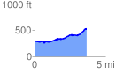
 3.662004 mi
 356.06 ft
 123.47 ft
 232.58 ft
 1.84 %
GPX Downloads: Track Route
![]()
|
| at: |
Tuskegee National Forest |
show on map
animate
3.662004 mi
356.06 ft
123.47 ft
232.58 ft
1.84 %