|
| at: |
Tuskegee National Forest |
Data from USFS GIS
 show on map
 animate
Trail users:


Elevation Profile
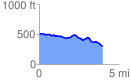
 3.987757 mi
 162.91 ft
 382.40 ft
 -219.49 ft
 1.82 %
GPX Downloads: Track Route
![]()
|
| at: |
Tuskegee National Forest |
show on map
animate
3.987757 mi
162.91 ft
382.40 ft
-219.49 ft
1.82 %