|
| at: |
Tuskegee National Forest |
Data from USFS GIS
 show on map
 animate
Trail users:


Elevation Profile
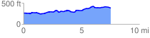
 7.614771 mi
 421.13 ft
 300.21 ft
 120.92 ft
 1.05 %
GPX Downloads: Track Route
![]()
|
| at: |
Tuskegee National Forest |
show on map
animate
7.614771 mi
421.13 ft
300.21 ft
120.92 ft
1.05 %