|
| at: |
Conecuh National Forest |
Data from USFS GIS
 show on map
 animate
Trail users:


Elevation Profile
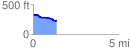
 1.388076 mi
 12.20 ft
 111.88 ft
 -99.68 ft
 1.53 %
GPX Downloads: Track Route
![]()
|
| at: |
Conecuh National Forest |
show on map
animate
1.388076 mi
12.20 ft
111.88 ft
-99.68 ft
1.53 %