|
| at: |
Conecuh National Forest |
Data from USFS GIS
 show on map
 animate
Trail users:


Elevation Profile
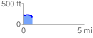
 0.706613 mi
 17.55 ft
 73.98 ft
 -56.43 ft
 1.98 %
GPX Downloads: Track Route
![]()
|
| at: |
Conecuh National Forest |
show on map
animate
0.706613 mi
17.55 ft
73.98 ft
-56.43 ft
1.98 %