|
| at: |
Conecuh National Forest |
Data from USFS GIS
 show on map
 animate
Trail users:


Elevation Profile
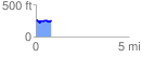
 0.828933 mi
 66.85 ft
 88.50 ft
 -21.65 ft
 2.02 %
GPX Downloads: Track Route
![]()
|
| at: |
Conecuh National Forest |
show on map
animate
0.828933 mi
66.85 ft
88.50 ft
-21.65 ft
2.02 %