|
| at: |
Conecuh National Forest |
Data from USFS GIS
 show on map
 animate
Trail users:


Elevation Profile
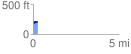
 0.270305 mi
 23.91 ft
 1.72 ft
 22.19 ft
 1.68 %
GPX Downloads: Track Route
![]()
|
| at: |
Conecuh National Forest |
show on map
animate
0.270305 mi
23.91 ft
1.72 ft
22.19 ft
1.68 %