|
| at: |
Conecuh National Forest |
Data from USFS GIS
 show on map
 animate
Trail users:


Elevation Profile
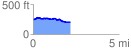
 2.171513 mi
 95.75 ft
 140.22 ft
 -44.46 ft
 1.22 %
GPX Downloads: Track Route
![]()
|
| at: |
Conecuh National Forest |
show on map
animate
2.171513 mi
95.75 ft
140.22 ft
-44.46 ft
1.22 %