|
| at: |
Conecuh National Forest |
Data from USFS GIS
 show on map
 animate
Trail users:


Elevation Profile
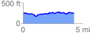
 4.312335 mi
 231.80 ft
 247.38 ft
 -15.57 ft
 1.09 %
GPX Downloads: Track Route
![]()
|
| at: |
Conecuh National Forest |
show on map
animate
4.312335 mi
231.80 ft
247.38 ft
-15.57 ft
1.09 %