|
| at: |
Conecuh National Forest |
Data from USFS GIS
 show on map
 animate
Trail users:


Elevation Profile
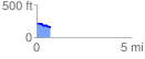
 0.731585 mi
 13.36 ft
 73.76 ft
 -60.40 ft
 1.91 %
GPX Downloads: Track Route
![]()
|
| at: |
Conecuh National Forest |
show on map
animate
0.731585 mi
13.36 ft
73.76 ft
-60.40 ft
1.91 %