|
| at: |
Conecuh National Forest |
Data from USFS GIS
 show on map
 animate
Trail users:


Elevation Profile
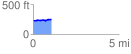
 1.061085 mi
 42.22 ft
 20.25 ft
 21.97 ft
 0.75 %
GPX Downloads: Track Route
![]()
|
| at: |
Conecuh National Forest |
show on map
animate
1.061085 mi
42.22 ft
20.25 ft
21.97 ft
0.75 %