|
| at: |
Conecuh National Forest |
Data from USFS GIS
 show on map
 animate
Trail users:


Elevation Profile
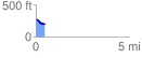
 0.481248 mi
 10.32 ft
 78.32 ft
 -67.99 ft
 3.08 %
GPX Downloads: Track Route
![]()
|
| at: |
Conecuh National Forest |
show on map
animate
0.481248 mi
10.32 ft
78.32 ft
-67.99 ft
3.08 %