|
| at: |
Conecuh National Forest |
Data from USFS GIS
 show on map
 animate
Trail users:


Elevation Profile
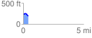
 0.411888 mi
 19.53 ft
 60.54 ft
 -41.01 ft
 2.78 %
GPX Downloads: Track Route
![]()
|
| at: |
Conecuh National Forest |
show on map
animate
0.411888 mi
19.53 ft
60.54 ft
-41.01 ft
2.78 %