|
| at: |
Conecuh National Forest |
Data from USFS GIS
 show on map
 animate
Trail users:


Elevation Profile
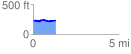
 1.339516 mi
 69.17 ft
 57.52 ft
 11.65 ft
 0.98 %
GPX Downloads: Track Route
![]()
|
| at: |
Conecuh National Forest |
show on map
animate
1.339516 mi
69.17 ft
57.52 ft
11.65 ft
0.98 %