|
| at: |
Conecuh National Forest |
Data from USFS GIS
 show on map
 animate
Trail users:


Elevation Profile
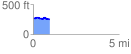
 0.956540 mi
 44.34 ft
 62.43 ft
 -18.09 ft
 1.24 %
GPX Downloads: Track Route
![]()
|
| at: |
Conecuh National Forest |
show on map
animate
0.956540 mi
44.34 ft
62.43 ft
-18.09 ft
1.24 %