|
| at: |
Conecuh National Forest |
Data from USFS GIS
 show on map
 animate
Trail users:


Elevation Profile
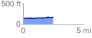
 2.497233 mi
 60.81 ft
 26.41 ft
 34.39 ft
 0.46 %
GPX Downloads: Track Route
![]()
|
| at: |
Conecuh National Forest |
show on map
animate
2.497233 mi
60.81 ft
26.41 ft
34.39 ft
0.46 %