|
| at: |
Conecuh National Forest |
Data from USFS GIS
 show on map
 animate
Trail users:


Elevation Profile
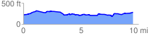
 9.676146 mi
 474.29 ft
 413.67 ft
 60.62 ft
 0.93 %
GPX Downloads: Track Route
![]()
|
| at: |
Conecuh National Forest |
show on map
animate
9.676146 mi
474.29 ft
413.67 ft
60.62 ft
0.93 %