|
| at: |
Conecuh National Forest |
Data from USFS GIS
 show on map
 animate
Trail users:


Elevation Profile
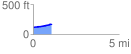
 1.079497 mi
 57.36 ft
 0.66 ft
 56.71 ft
 1.01 %
GPX Downloads: Track Route
![]()
|
| at: |
Conecuh National Forest |
show on map
animate
1.079497 mi
57.36 ft
0.66 ft
56.71 ft
1.01 %