|
| at: |
Conecuh National Forest |
Data from USFS GIS
 show on map
 animate
Trail users:


Elevation Profile
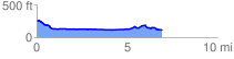
 7.046277 mi
 214.21 ft
 328.45 ft
 -114.24 ft
 0.88 %
GPX Downloads: Track Route
![]()
|
| at: |
Conecuh National Forest |
show on map
animate
7.046277 mi
214.21 ft
328.45 ft
-114.24 ft
0.88 %