|
| at: |
Conecuh National Forest |
Data from USFS GIS
 show on map
 animate
Trail users:


Elevation Profile
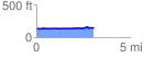
 3.043503 mi
 55.06 ft
 40.57 ft
 14.49 ft
 0.34 %
GPX Downloads: Track Route
![]()
|
| at: |
Conecuh National Forest |
show on map
animate
3.043503 mi
55.06 ft
40.57 ft
14.49 ft
0.34 %