|
| at: |
Conecuh National Forest |
Data from USFS GIS
 show on map
 animate
Trail users:


Elevation Profile
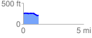
 1.293448 mi
 51.02 ft
 86.55 ft
 -35.54 ft
 1.27 %
GPX Downloads: Track Route
![]()
|
| at: |
Conecuh National Forest |
show on map
animate
1.293448 mi
51.02 ft
86.55 ft
-35.54 ft
1.27 %