|
| at: |
Conecuh National Forest |
Data from USFS GIS
 show on map
 animate
Trail users:


Elevation Profile
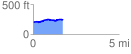
 1.743343 mi
 99.69 ft
 60.48 ft
 39.21 ft
 1.08 %
GPX Downloads: Track Route
![]()
|
| at: |
Conecuh National Forest |
show on map
animate
1.743343 mi
99.69 ft
60.48 ft
39.21 ft
1.08 %