| at: |
Conecuh National Forest |
Data from USFS GIS
 show on map
 animate
Trail users:


Elevation Profile
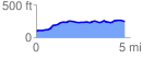
 4.713144 mi
 271.70 ft
 119.79 ft
 151.91 ft
 1.09 %
GPX Downloads: Track Route
![]()
| at: |
Conecuh National Forest |
show on map
animate
4.713144 mi
271.70 ft
119.79 ft
151.91 ft
1.09 %