|
| at: |
Conecuh National Forest |
Data from USFS GIS
 show on map
 animate
Trail users:


Elevation Profile
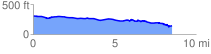
 8.548876 mi
 222.75 ft
 387.84 ft
 -165.09 ft
 0.86 %
GPX Downloads: Track Route
![]()
|
| at: |
Conecuh National Forest |
show on map
animate
8.548876 mi
222.75 ft
387.84 ft
-165.09 ft
0.86 %