|
| at: |
Conecuh National Forest |
Data from USFS GIS
 show on map
 animate
Trail users:


Elevation Profile
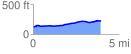
 3.931620 mi
 146.71 ft
 45.25 ft
 101.46 ft
 0.71 %
GPX Downloads: Track Route
![]()
|
| at: |
Conecuh National Forest |
show on map
animate
3.931620 mi
146.71 ft
45.25 ft
101.46 ft
0.71 %