|
| at: |
Conecuh National Forest |
Data from USFS GIS
 show on map
 animate
Trail users:


Elevation Profile
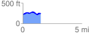
 1.507732 mi
 116.27 ft
 103.42 ft
 12.85 ft
 1.46 %
GPX Downloads: Track Route
![]()
|
| at: |
Conecuh National Forest |
show on map
animate
1.507732 mi
116.27 ft
103.42 ft
12.85 ft
1.46 %