|
| at: |
Conecuh National Forest |
Data from USFS GIS
 show on map
 animate
Trail users:


Elevation Profile
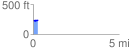
 0.266490 mi
 11.22 ft
 2.46 ft
 8.76 ft
 0.80 %
GPX Downloads: Track Route
![]()
|
| at: |
Conecuh National Forest |
show on map
animate
0.266490 mi
11.22 ft
2.46 ft
8.76 ft
0.80 %