|
| at: |
Conecuh National Forest |
Data from USFS GIS
 show on map
 animate
Trail users:


Elevation Profile
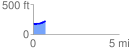
 0.712384 mi
 54.81 ft
 17.27 ft
 37.54 ft
 1.46 %
GPX Downloads: Track Route
![]()
|
| at: |
Conecuh National Forest |
show on map
animate
0.712384 mi
54.81 ft
17.27 ft
37.54 ft
1.46 %