|
| at: |
Conecuh National Forest |
Data from USFS GIS
 show on map
 animate
Trail users:


Elevation Profile
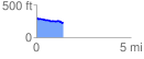
 1.428134 mi
 31.42 ft
 105.48 ft
 -74.06 ft
 1.40 %
GPX Downloads: Track Route
![]()
|
| at: |
Conecuh National Forest |
show on map
animate
1.428134 mi
31.42 ft
105.48 ft
-74.06 ft
1.40 %