| at: |
Conecuh National Forest |
Data from USFS GIS
 show on map
 animate
Trail users:


Elevation Profile
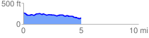
 5.011102 mi
 167.45 ft
 279.69 ft
 -112.24 ft
 1.06 %
GPX Downloads: Track Route
![]()
| at: |
Conecuh National Forest |
show on map
animate
5.011102 mi
167.45 ft
279.69 ft
-112.24 ft
1.06 %