|
| at: |
Conecuh National Forest |
Data from USFS GIS
 show on map
 animate
Trail users:


Elevation Profile
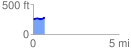
 0.674464 mi
 50.29 ft
 21.61 ft
 28.68 ft
 1.41 %
GPX Downloads: Track Route
![]()
|
| at: |
Conecuh National Forest |
show on map
animate
0.674464 mi
50.29 ft
21.61 ft
28.68 ft
1.41 %