|
| at: |
Conecuh National Forest |
Data from USFS GIS
 show on map
 animate
Trail users:


Elevation Profile
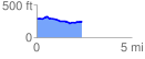
 2.402285 mi
 115.13 ft
 149.88 ft
 -34.75 ft
 1.18 %
GPX Downloads: Track Route
![]()
|
| at: |
Conecuh National Forest |
show on map
animate
2.402285 mi
115.13 ft
149.88 ft
-34.75 ft
1.18 %