|
| at: |
Conecuh National Forest |
Data from USFS GIS
 show on map
 animate
Trail users:


Elevation Profile
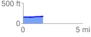
 1.698366 mi
 25.46 ft
 5.45 ft
 20.02 ft
 0.28 %
GPX Downloads: Track Route
![]()
|
| at: |
Conecuh National Forest |
show on map
animate
1.698366 mi
25.46 ft
5.45 ft
20.02 ft
0.28 %