|
| at: |
Bankhead National Forest |
Data from USFS GIS
 show on map
 animate
Trail users:


Elevation Profile
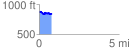
 0.787768 mi
 94.96 ft
 117.84 ft
 -22.88 ft
 2.83 %
GPX Downloads: Track Route
![]()
|
| at: |
Bankhead National Forest |
show on map
animate
0.787768 mi
94.96 ft
117.84 ft
-22.88 ft
2.83 %