|
| at: |
Bankhead National Forest |
Data from USFS GIS
 show on map
 animate
Trail users:


Elevation Profile
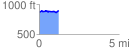
 1.233991 mi
 92.57 ft
 65.58 ft
 26.99 ft
 1.42 %
GPX Downloads: Track Route
![]()
|
| at: |
Bankhead National Forest |
show on map
animate
1.233991 mi
92.57 ft
65.58 ft
26.99 ft
1.42 %