|
| at: |
Bankhead National Forest |
Data from USFS GIS
 show on map
 animate
Trail users:


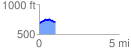
Elevation Profile
 1.018493 mi
 99.69 ft
 66.34 ft
 33.36 ft
 1.85 %
GPX Downloads: Track Route
![]()
|
| at: |
Bankhead National Forest |
show on map
animate
1.018493 mi
99.69 ft
66.34 ft
33.36 ft
1.85 %